A Photo Finish for the Wild Rivers Campaign

Brookings, Ore. | As the new year begins we’re teeming with joy for native fish and wild rivers! It was a photo finish, but with just 48 hours left in 2016, the Assistant Secretary for Lands and Mineral Management, Janice Schneider, signed the public land order making official a 20-year mineral withdrawal for southwest Oregon!
What does this mean? The Assistant Secretary's signature is the culmination of years of grassroots work including thousands of letters and phone calls, 75,000 supportive comments, 3 packed public hearings, dozens of letters to the editor, house parties, and community presentations which thankfully transformed into two decades of protections from industrial strip mining for 101,000 acres of rugged public lands. These protections extend across the headwaters of the federally designated Wild and Scenic Smith and Illinois rivers as well as free-flowing Hunter Creek and Pistol River. Taken together, these protections will safeguard water quality and habitats for over a dozen remarkable wild salmon and steelhead populations, including threatened coho salmon, returning home to the most intact coastal ecosystem in the lower 48 states.
Equally important the Wild Rivers Campaign is a true testament to the power of local grassroots conservation. For nearly three years, River Stewards Dave Lacey, James Smith and Sunny Bourdon worked with their local communities, with neighbors, friends, local businesses and elected officials to build overwhelming local support for protections.
"Our campaign to stop this foreign mining corporation started with a simple petition I walked around Hunter Creek knocking on doors and talking with neighbors," said Dave Lacey, Hunter Creek River Steward. "When 99% of the residents in Hunter Creek signed on I knew that we had a chance to protect our place. My neighbors and local people were this campaign's greatest asset -- together we protected what we all love so much -- our wild rivers, our native fish and our home!"
"I am proud of our Wild Rivers Coast community for demonstrating what we value; clean rivers, healthy fish populations and a legacy of protecting our homewaters," said Smith and Chetco River Steward Sunny Bourdon.
Head brewer at Arch Rock Brewing and founding member of the Wild Rivers, Wild Brews Coalition, James Smith said, "We're protecting our fish, our rivers and our clean water economy. Thank you Congressman DeFazio and Senators Wyden and Merkley for protecting our homewaters and our livelihood."
This bottom up approach means that today, with significant protections secured for our native fish and wild rivers, our rural communities are celebrating as well. We cannot thank our local electeds and business leaders enough, including Mayor Popoff and the Gold Beach City Council, our Curry County Commissioners and the dozens of local business leaders that joined the coalition to protect our remarkable place.
A also extend a huge thank you to our Congressional champions whose leadership and dedicated staff members were responsive to our local effort all along. Thank you congressmen Peter DeFazio and Jared Huffman and senators Ron Wyden and Jeff Merkley! We look forward to working together to secure permanent protections for our place over the next 20 years!
Native Fish Society also wants to thank all of our campaign partners including Ann Vileisis and the Kalmiopsis Audubon Society, Barbara Ullian and Friends of the Kalmiopsis, Grant Werschkull and Patty McCleary at Smith River Alliance, Bonnie Gestring at Earthworks, and the whole crew at KS Wild, American Whitewater, Trout Unlimited and American Rivers. Our work together on this campaign is an all too rare example of how a diverse coalition of conservation groups can work together to achieve incredible results.
Last, but not least, a BIG THANK YOU to all of our members and campaign supporters. You signed action alerts and letters, wrote checks and supported our grassroots Wild Rivers Campaign for nearly three years! Without your help we could not have achieved this incredible victory. And if you believe in our work and want to see more victories like this in the future please donate to Native Fish Society or join us as a member. Thank you for your steadfast support!
Now the photo finish you’ve been waiting for. We hope you enjoy these incredible places and the native fish we protected together. Happy New Year!
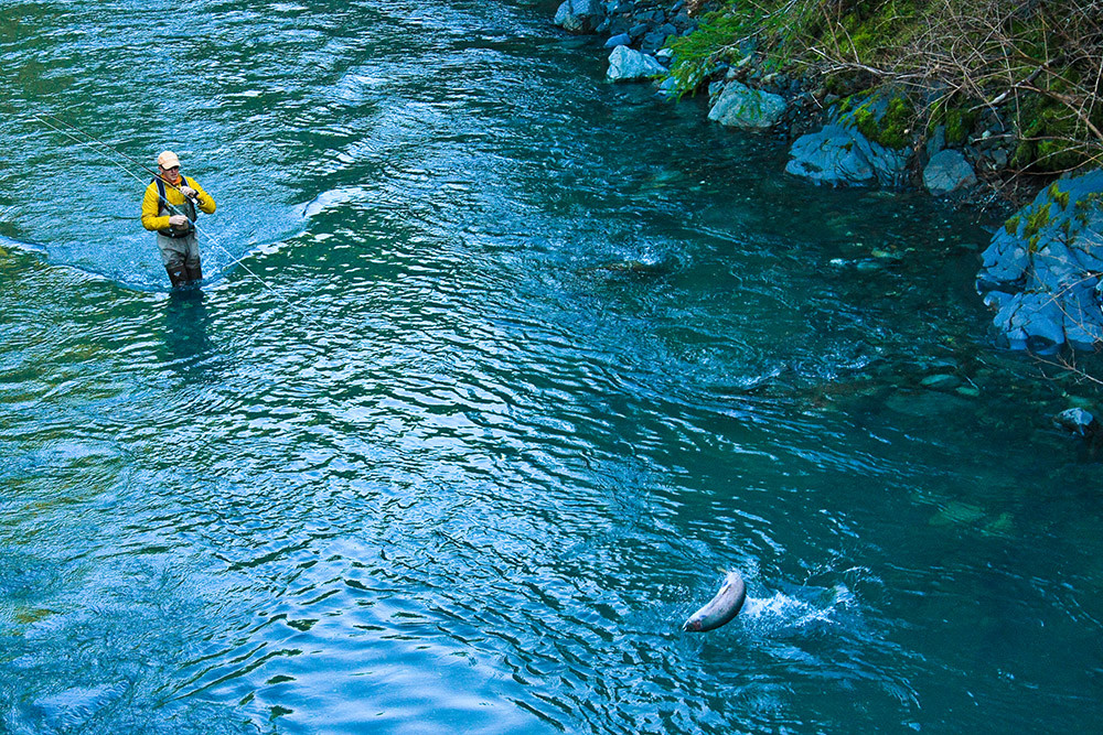
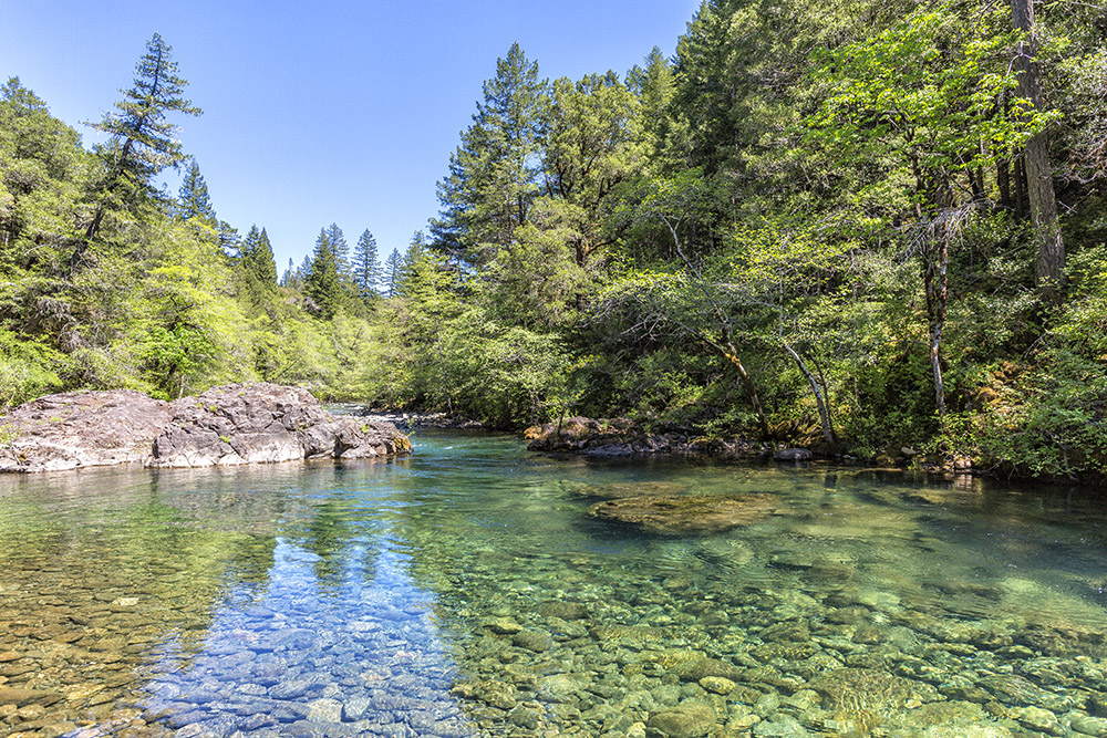
Hunter Creek
Hunter Creek is a free flowing stream known for its unique botanical values and all wild runs of fall Chinook, salmon, winter steelhead, threatened Coho salmon, sea run cutthroat and resident rainbow trout. Beginning at 3,500 ft on Sugarloaf Mountain in the Coastal Siskiyou Range, Hunter Creek drains nearly 45 sq. miles of land as it flows west to meet the Pacific just south of Gold Beach, OR. Hunter Creek includes two Bureau of Land Management Areas of Critical Environmental Concern: the North Fork Hunter Creek ACEC and the Hunter Creek Bog ACEC. Both of these areas are managed to preserve their unique natural values, including rare flowers like the insect eating cobra lily. To recognize Hunter Creek’s unusual combination of serpentine soils, high annual rainfall and close proximity to the coast, local citizens have proposed the Veva Stansell/Signal Buttes Botanical Area in the headwaters to protect its rare botanical values. Hunter Creek provides drinking water for residents in the lower basin who draw freshwater from nearly 100 shallow wells. Photograph taken on the lower mainstem of Hunter Creek, downstream of Red Flat Nickel Corps. proposed mine at the Red Flat site.
Photographer: Ken Morrish
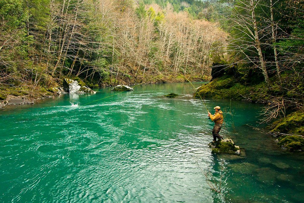
Pistol River
From its headwaters on the 4,220-foot Snow Camp Mountain, the Pistol River flows 21 miles through the Southern Oregon Coast Range to the Pacific Ocean 10 miles south of Gold Beach, OR. Over 55% of the Pistol River’s 105 sq. mile watershed is public land managed by the Rogue River – Siskiyou National Forest and the Bureau of Land Management. Thanks to its largely unaltered state, the Pistol River’s estuary is one of only 5 in Oregon that the state has classified as ‘natural.’ The headwaters of the North Fork of the Pistol border the Red Flat Botanical Area and support unique serpentine plant communities. The Pistol River is dam free and supports all wild populations of fall Chinook, winter steelhead, fall steelhead, threatened Coho salmon, sea run cutthroat trout and resident rainbow trout. Prized for its rugged and beautiful course to the sea, the Pistol River also provides drinking water for residents in the lower basin who draw from nearly 100 shallow wells. Photograph taken on the lower mainstem of Pistol River, downstream of Red Flat Nickel Corps. proposed mine at the Red Flat site.
Photographer: Ken Morrish
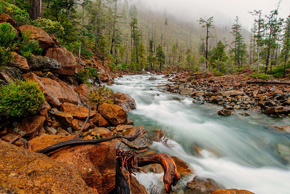
Baldface Creek (North Fork of the Smith River tributary)
Baldface Creek flows southwest out of Oregon’s Kalmiopsis Wilderness and through the South Kalmiopsis Roadless Area to join the North Fork Smith River just before it enters California. Baldface Creek is known for its pristine waters and gentle gradient, which makes it one of the North Fork Smith’s most important tributaries for protected Coho salmon, fall Chinook salmon, winter steelhead and cutthroat trout. Forest Service managers were so impressed with Baldface Creek they found it eligible for the highest honor that can be bestowed on any American waterway – as a “Wild River” under the National Wild and Scenic System. In 2004, the Forest Service proposed adding the Baldface Creek watershed to the Kalmiopsis Wilderness. Waters originating in Baldface Creek are part of the freshwater drinking supply for the communities of Gasquet, Hiouchi and Crescent City, CA. Photograph taken approximately 1/2 mile above the confluence with the North Fork of the Smith River. Red Flat Nickel Corps. proposed Cleopatra site is located upstream of this photo.
Photographer: Ken Anderson
North Fork of the Smith River
The North Fork of the Smith River is a pristine tributary to California’s famous Smith River, originating high in Oregon’s Kalmiopsis Wilderness. For 28 miles the North Fork flows south, collecting the pure waters of its many wild tributaries until it joins the Middle Fork Smith in California. In both Oregon and California the North Fork is designated as a National Wild and Scenic River. The North Fork and its tributaries provide important habitat for the Smith River’s famously large and abundant fall Chinook salmon and winter steelhead populations, as well as threatened Coho salmon. The Smith River is considered one of the premier salmon strongholds on the entire Pacific Coast. The North Fork is also considered one of California’s most scenic and challenging whitewater adventures, featuring 14 miles of Class III and IV rapids. Waters originating in the North Fork of the Smith River are part of the freshwater drinking supply for the communities of Gasquet, Hiouchi, and Crescent City, CA. Photograph taken on the National Wild and Scenic North Fork of the Smith River in California, upsteam of Gasquet, CA. The river section pictured is downstream of Red Flat Nickel Corps. proposed mine at the Cleopatra site.
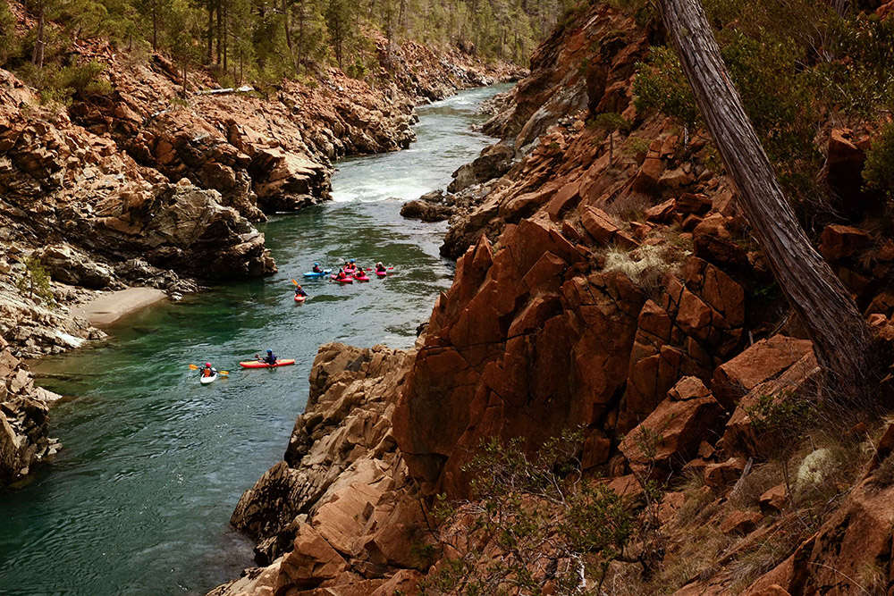
Photographer: Nate Wilson
Rough and Ready Creek (Illinois River tributary)
Although desert-like in appearance, Rough and Ready Creek is a botanical wonderland thanks to its unique serpentine soils, crystal clear water and high annual rainfall. The headwaters of Rough and Ready Creek are tucked high in the Kalmiopsis Wilderness. It then flows east through the South Kalmiopsis Roadless Area to meet the West Fork Illinois River just south of Cave Junction, OR. Rough and Ready Creek contains the highest concentration of rare plants in Oregon and is eligible for National Wild and Scenic designation – the highest honor that can be bestowed upon an American waterway. In 2004, the Forest Service proposed adding much of the creek to the Kalmiopsis Wilderness. Rough and Ready Creek is home to wild salmon and steelhead, which make their way up the Illinois to spawn in the fall and winter. Waters originating in Rough and Ready Creek and the West Fork Illinois are part of the freshwater drinking supply for Cave Junction, Kerby, Agness and Gold Beach, OR. Photograph taken in the South Kalmiopsis Roadless Area on the USFS Eligible Wild and Scenic North Fork Rough and Ready Creek (Wild Section) below one of two RNR Project proposed mines sites
Photographer: Nate Wilson
Illinois River
The National Wild and Scenic Illinois River begins in the rugged Siskiyou Mountains near the California border and flows northwest through one of the most inaccessible river canyons in the lower 48, before merging with the Rogue River near Agness, OR. The 56-mile Illinois River is famous for its abundant whitewater and 50-mile National Wild and Scenic section, much of which courses through the Kalmiopsis Wilderness. For whitewater enthusiasts, the Illinois’ 150 rapids– including 11 Class IVs and 1 Class V known as ‘The Green Wall’ (pictured)–create one of the most challenging whitewater adventures in the U.S. The Illinois River is a stronghold for all wild populations of Coho and fall Chinook salmon, winter steelhead and cutthroat trout – a rare distinction. Waters that originate in the Illinois River watershed are part of the freshwater drinking supply for O’Brien, Cave Junction, Kerby, Selma, Agness and Gold Beach, OR. Photograph taken at the Green Wall rapid in the Kalmiopsis Wilderness on the National Wild and Scenic Illinois River. The river section pictured is downstream of
RNR Resources two proposed mine sites.
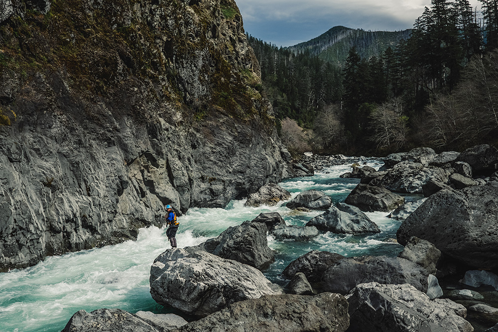
Photographer: Nate Wilson